


| < - > Construct — Routing - Track - Route — VELOMAP — 3D Route Builder — GPX Viewer |
VADEMECUM :
ROUTING, TRACK, ROUTE, conversion…
In order to provide your GPS with the data that will allow it to guide you effectively, you need to be familiar with the differences, nuances and subtleties of the data.
It is important to take into consideration:
- Terminologies associated with mapping and GPS data.
- Data types and their associated files.
- How conversions between these data types are performed.
TERMINOLOGY AND DEFINITION
Cartography side: |
GPS side: |
|
|
To find out what's in the GPX "lucky dip" file… TRACK or ROUTE?…
Just open it with any editor, and watch the content. From the very first lines:
- A TRACK file will contain XML tags named <trk>, <trkseg>, <trkpt>.
- A ROUTE file will contain XML tags named <rte>, <rtept>.
TRACK
By definition a TRACK 'sticks' to the virtual (mapping) or real (GPS) route:
Cartography side: |
GPS side: |
The virtual path, created by the cartography, sticks (follows) to the curves perfectly because of the use of a considerable number of points, very close to each other… |
The actual route, recorded by the GPS as you move, sticks (follows) to the curves almost perfectly with a considerable number of points, very close together. This usually occurs after many days of recording without a reset. |
Typically a daily TRACK of a few tens of kilometres contains thousands of points.
ROUTE
A ROUTE does not perfectly fit the curves of the course.
A ROUTE cannot and MUST not contain as many points as a TRACK:
- It CANNOT, because GPS has two different memories, one for ROUTES and one for TRACES; and the memory size occupied by a ROUTE point is much larger than a TRACED point.
In practice the ROUTE memory can contain a maximum of 250 point in the most powerful GPS on the market.
- It MUST NOT because GPS guidance would be of poor quality. We will see in detail in the next chapter 'Trail to Route Conversion'.
CONVERSION OF TRACK TO ROUTE
PRELIMINARY FOREWORD
The TRACK built by the ROUTING function of a card must therefore be CONVERTED to ROUTE.
As we have seen above a TRACÉ can have thousands of points.
TRACK in Black lines and dots. A considerable number of points, very close together… |
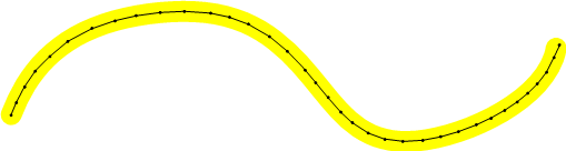 |
| T r a f f i c l a n e i n Y e l l o w | |
A ROUTE must have an optimum number of points. This optimum is variable, but it answers some rules rarely written but nevertheless essential:
- It should not be too many points.
- It must have enough points.
A ROUTE SHOULD NOT HAVE TOO MANY POINTS
At each point the GPS emits a small alert to draw the pilot's attention to the 'change of direction'. If the ROUTES have too many points:
- The GPS would produce its alerts in bursts, to the limit one every meter travelled. That would be aberrant and unworkable. It would be useless.
- Guidance would be imprecise. Because when the GPS 'sees' a point arriving it switches to a simplified super-zoomed display. It displays the vector BEFORE the point and the vector AFTER the point. For example, in a crow's-foot crossroads, the angle between the two vectors should be representative of the change in direction you will have to make. With too many points, we would have successively as we advance into the crossroads changes in the zoom display with very small angles between the 2 vectors. We would therefore not know which is the right junction to take until very late in the junction. The goal is to know BEFORE the intersection where to go in the intersection.
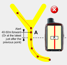
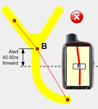
Several points too close |
The point before the change of direction is misplaced. The GPS alert will be very ambiguous. |
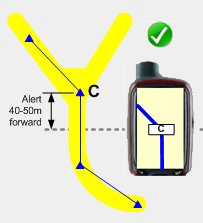
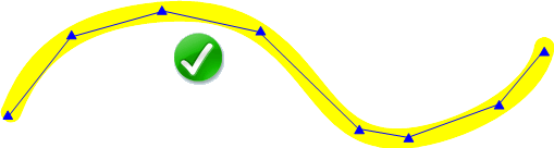
Good disposition. |
 |
 |
 |
T r a f f i c l a n e i n Y e l l o w |
||
A ROUTE MUST HAVE ENOUGH POINTS
You have to go through the whole ROUTE to make sure that there are enough points left, and that these points are well placed, to have:
- Precise and reliable GPS guidance (don't miss any changes in direction!).
- Reliable information on the remaining distance to be covered.
- Pertinent information on the cumulative difference in altitude.
ENSURE ACCURATE AND RELIABLE GPS GUIDANCE
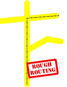
Rough ROUTING TRACK |
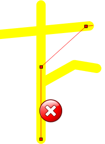
ROUTE after conversion, risk of mistake |
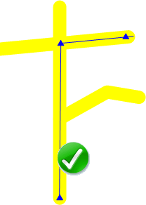
Converted ROUTE AND manually corrected |
 |
 |
 |
T r a f f i c l a n e i n Y e l l o w |
||
ENSURE RELIABLE DISTANCE INFORMATION
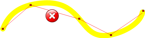
If a route has a lot of bends and curves and these are 'vectorized' too coarsely (with too few points), the final total mileage of the ROUTE may be significantly lower than the reality. This can be very annoying in the appreciation of the planning of his day of hike.
Not enough points for the mileage forecast will be wrong. |
Good distribution of points (mileage criterion) |
 ROUTE in lines and red dots. ROUTE in lines and red dots. |
 ROUTE in lines and blue dots. ROUTE in lines and blue dots. |
T r a f f i c l a n e i n Y e l l o w |
|
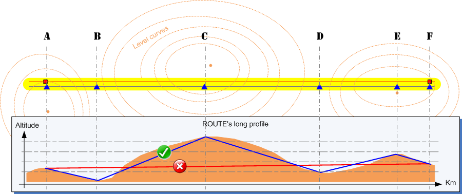
ENSURE ACCURATE INFORMATION ON CUMULATIVE HEIGHT DIFFERENCE
If a route includes significant relief, it is necessary to have EVEN IF THE ROUTE IS RECTILLED supernumerary points positioned at the main changes in contour (altitude).
This allows you to see the difficulty of each planned stage, not only in terms of kilometres to be covered, but also in terms of the cumulative positive difference in altitude.
In the case of a significant cumulative difference in altitude, this is the case:
- Leads to a decrease in the average hourly rate and an increase in the foreseeable journey time.
- May possibly lead to a reduction in the mileage to be covered for a stage with a high gradient.
Below is an example:
- In Yellow the traffic lane
- In Red the ROUTE marked with only 2 points (A and F).
- In Blue the ROUTE marked with 6 points. 4 points have been added:
- Points B and D at the low points of the portion.
- Points C and E at the high points of the portion.
CONVERSION
It will consist of:
- To load in a mapping software the TRACK from the ROUTING.
- To launch the appropriate function in the software for the conversion to ROUTE (see the pages dedicated to the different cartography software for the specificities of each one).
- Carry out a detailed review of the entire ROUTE thus generated.
- If in the ROUTE of a stage you are stuck at the maximum number of points (specific to your GPS), and there are not enough points for a precise and reliable guidance then :
- The ROUTE should be split in two.
- During the hike, the stage of that day will be done using 2 ROUTES. At the end of ROUTE n°1 it will be enough to stop for a few seconds to activate ROUTE n°2 in the GPS.