


| < - > Construct — Routing - Track - Route — VELOMAP — 3D Route Builder — GPX Viewer |
CREATE YOUR ROUTE (ITINERARY)
WITH VELOMAP (UNDER GARMIN BASECAMP)
Stemming from the OpenStreetMap Project (OSM), the FREE VELOMAP solution makes it possible to build cycling routes EVERYWHERE IN THE WORLD.
For historical generalities you can consult : Wikipedia-Openstreetmap.
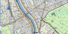
OPENSTREETMAP (On-line mapping on the WEB)
It's similar to Google-Maps except that it's non-commercial (which, in itself, doesn't matter).
but EVERYWHERE THERE IS A CYCLING CARD LAYER!!!
Whichever tool you use to create your itinerary you can immediately visualize the region of the world that interests you WITH ITS CYCLING POSSIBILITIES: example SWITZERLAND (the "Bicycle Map" layer is pre-activated by our link).
VELOMAP (Off-line mapping on computer under BASECAMP)
To really build your route you need a vector mapping tool.
The VELOMAP project is based on OpenStreetMap cartographic data (with of course the CYCLABLE DATA) and including them in national maps (e.g. France, Germany…) that can be installed on a computer.
Happy owners of Garmin GPS we use their software BASECAMP. It's a Windows (or Mac) software to install on your PC, free download. The cartography included is ridiculous and unusable. Garmin offers its maps for a fee. But the goal here is to use it by installing a FREE and SPECIALIZED VELOMAP version.
VELOMAP maps are to DOWNLOAD HERE :
- You can download the country or countries you are interested in.
- However WARNING, only one map (ONLY ONE COUNTRY) can be displayed at any given time.
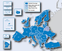
- By making a modest Contribution-Donation (20€ the first year, 13€ the following years) it is possible to obtain maps grouped by continents. Thus with the map 'Continent Europe' we're showing all of Europe simultaneously. This way you can trace your routes across several countries without any complication or juggling.
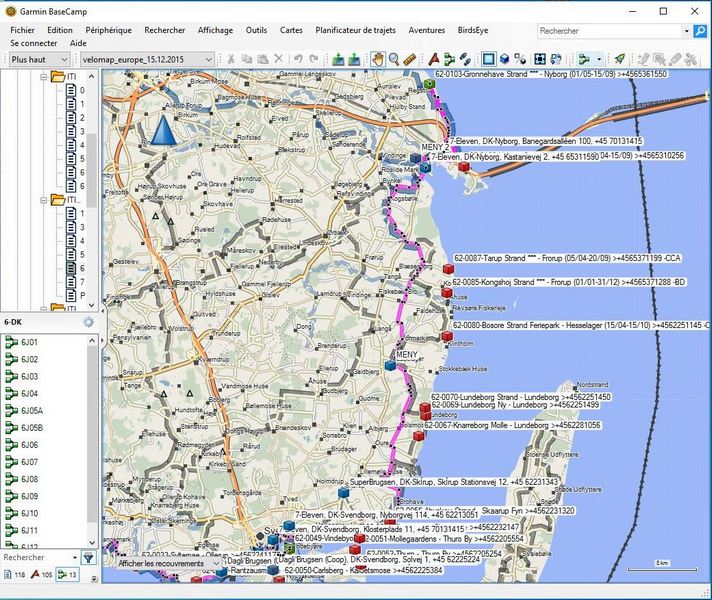
After installing the maps, one builds his complete route with the BASECAMP functions.
Once the routes (ROUTES) are created, they are sent from BASECAMP to the GPS, connecting it to the computer by USB cable.
MAPPING IN GPS
In the GPS it is essential to load a vector map.
This allows:
- to constantly follow his route (his ROUTE) on the map background.
- to be able to have a guide (a ROUTING) if you have to change your itinerary unexpectedly or if you have local visits to make (as in big cities.
It is possible to send the VELOMAP cartography to the GPS, so you benefit from the free of charge until the end.
This is not our choice. In fact we realized that the real time ROUTING in the GPS by VELOMAP was not efficient and subject to errors; and more serious to BUGS that plant the GPS.
We preferred to buy the GARMIN map 'CITY NAVIGATOR EUROPE' (for our playground in Europe… as its name suggests), also installed on the computer and co-used in BASECAMP. The precision on the field is excellent and the ROUTING much more efficient.
So we use two maps:
- The free VELOMAP, which is used exclusively to create routes on computer in BASECAMP.
- The chargeable GARMIN 'CITY NAVIGATOR EUROPE' which is sent from the computer to the GPS and used in the GPS in the field.
LONG PROFILE
Knowledge of the Longitudinal Profile is essential for anticipating difficulties and managing the daily pace.

One solution is to export the ROUTE created in BASECAMP into a GPX file, then import it into Google-Earth.
In Google-Earth you have to right-click on the imported route and then choose the option 'Show Elevation Profile' in the contextual menu.
The big problem is that this profile is FALSE, as it is roughly based on the global vision scale of the route.
To make it EXACT you have to zoom in very hard on the origin of the route and then move the route on the screen to scan the entire route, but be careful not to do so too fast to give the application time to retrieve altitude data from ALL route points. You can see in real time that the profile changes considerably, becomes more complex, and finally becomes complete and true. This is therefore long, uncertain and tedious..
Another, quasi-automatic solution is to use software that uses the Google-Earth engine to retrieve altitudes. This solution is described on the page 3D-ROUTE-BUILDER.
SMARTPHONES
In August 2016 Julien, a website visitor, sent me a message telling me about the interest of mobile applications and associated offline mapping. This corresponds to a guidance on Smartphones.
Personally I use intensively Smartphone guidance on foot. On a bike I consider dedicated GPS guidance much more powerful, reliable and above all RESISTANT to shocks and rain.
I haven't tested the solutions that Julien quoted and described to me. However for those who would be interested, they are the following:
- Offline map based on OpenStreetMap: openandromaps.org.
- Apps OsmAndand offline maps.
- OruxMaps on Google Play and some maps here.
These solutions seem to me to be somewhat confidential and still not widely disseminated and/or used. Are they reliable and efficient?
Do not hesitate to send me your feedback to know if these solutions are relevant.