


Cyclo-hiking LYON - LE PUY-EN-VELAY - PARIS
DOWNLOAD file
of the detailed route…
GENERAL DATA
| Country | Departures | Arrivals | Tracks | Distance | Year |
FRANCE |
LYON |
PARIS |
The ViaRhôna, |
Realized : 1,305 km Full theory: 1,006 km |
2025 |
SOURCING :
MAPS
|
ACCOMODATIONS
|
|
|
FEEDBACK OF EXPERIENCE
Details of the terrain:
Section |
Distance |
Elevation + |
m/km |
|---|---|---|---|
ViaRhôna from Lyon to Andancette |
81 km | 295 m | 3,6 |
Connection Andancette - Annonay |
16 km | 421 m | 26 |
Via Fluvia from Annonay to Lavoûte-sur-Loire whose part close Bourg-Argental |
93 km 360 m |
1 578 m 70 m |
16,9 194 (19,4%) |
Connection Lavoûte-sur-Loire - Saint-Arcons-d'Allier |
64 km | 1 229 m | 19,2 |
Via Allier from Saint-Arcons-d'Allier to Moulins |
256 km | 2 316 m | 9 |
Connection Moulins - Montluçon |
69 km | 756 m | 10,9 |
Canal du Berry from near Montluçon to Bourges |
128 km | 533 m | 4,2 |
Connection Bourges - Briare |
92 km | 884 m | 9,6 |
Canal de Briare from Briare to Rogny-les-7-écluses |
22 km | 141 m | 6,4 |
Canal du Loing from Rogny-les-7-écluses to Saint-Mammès |
88 km | 327 m | 3,7 |
Seine from Saint-Mammès to Paris |
97 km | 373 m | 3,8 |
| TOTAL | 1 006 km |
8 853 m |
8,8
|
VIARHÔNA
From Lyon to Givors, the route takes pitiful paths, moreover the environment is very unpleasant. From Givors to Andancette an enchanting moment is located between Tupin-et-Semons and Condrieu with the superb Île-du-Beurre.
CONNECTION ANDANCETTE - ANNONAY
Our personalized connection through Thorrenc, Saint-Cyr and Davézieux allows you to climb to Annonay in peace by a road with almost zero traffic. Beautiful panoramic views of the Rhone valley.
VIA FLUVIA
The Via Fluvia connects the Rhône valley to the high lands of the Loire. This greenway is fully superb, natural, green and pleasant.
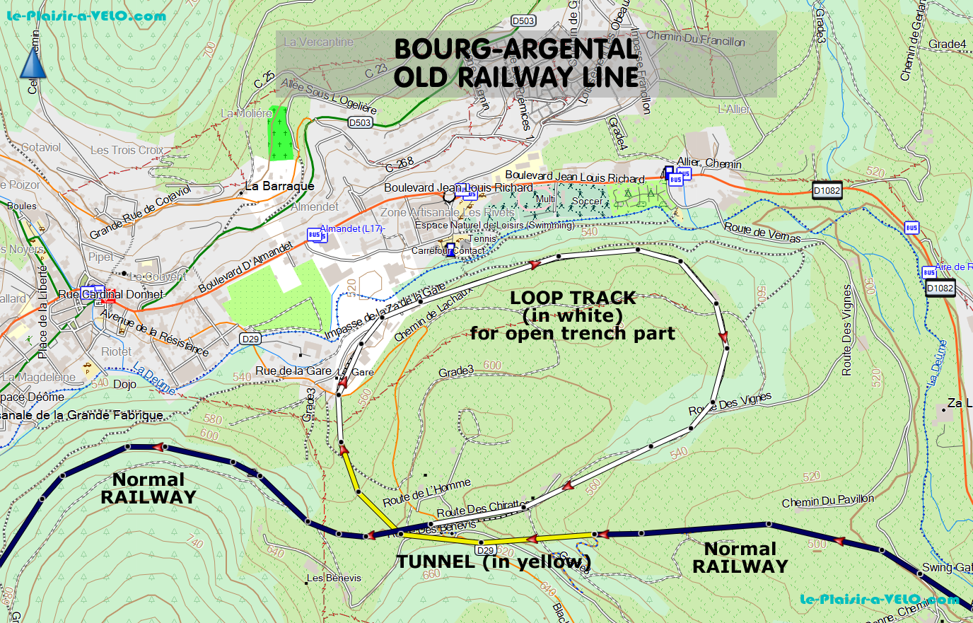
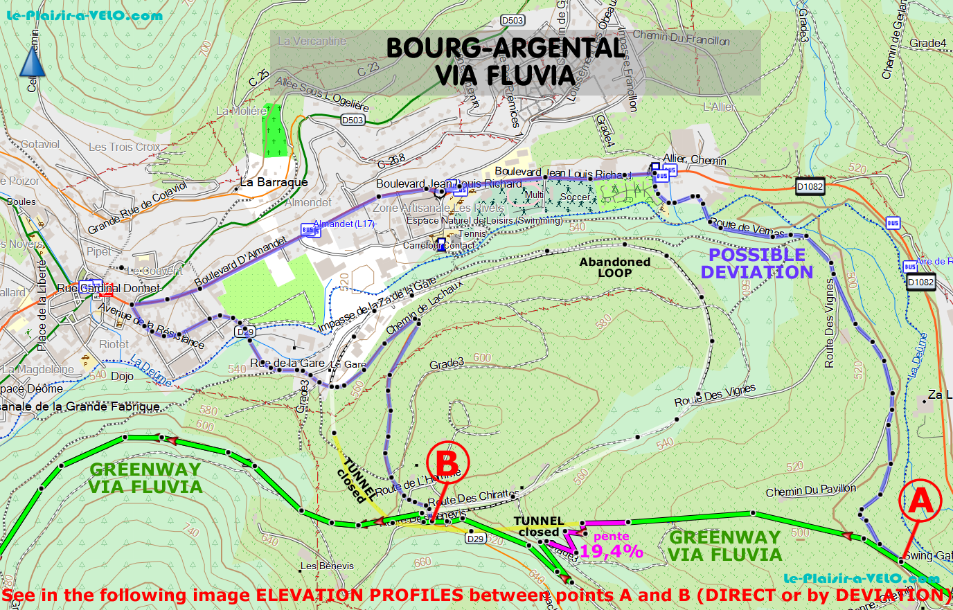
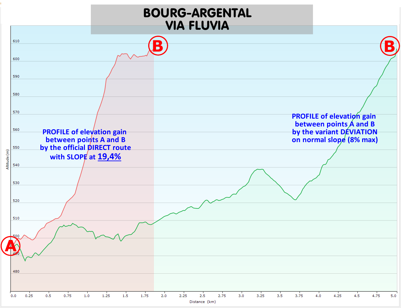
There is a quite small crazy portion located in Bourg-Argental: 19.4% average slope over 360 m!
The origin of this curiosity comes from the fact that to face this mini cliff, the railway ran through a loop consisting of a tunnel ("Tunnel de l'Homme") and a trench. So the slope was gradual. But the creators of the Via Fluvia ignored the old local route by replacing it with a direct path in the cliff with a set of hairpin bends. This while the tunnel is still in a state to be reused.
This kind of French economy is detrimental to families with children, because it’s either a huge effort, or turning away by a deviation (indicated on the spot)… deviation that passes by the nearest road… which is in heavy traffic! We passed through the cliff at 19.4%… hard!
A second concern is located further to the "Col du Tracol". Once again, the old railway track used a tunnel. Tunnel also in capacity to be reused. But unfortunately it remains closed. In the region, there is a fierce opposition from environmentalists. Which would invoke the protection of the bats that hibernate there. In other regions, this kind of situation is rationally and intelligently resolved by closing such a tunnel during the winter. There are therefore two possible hypotheses: either the local ecologists are even less intelligent and more ideologues than elsewhere, or the political decision-makers/investors take advantage of this opposition to make savings as they do in Bourg-Argental. Still, here the danger is for all cyclists: the route is sent directly on the heavy traffic road (with many trucks). Well done, the environmentalists and the politicians... they are crazy.
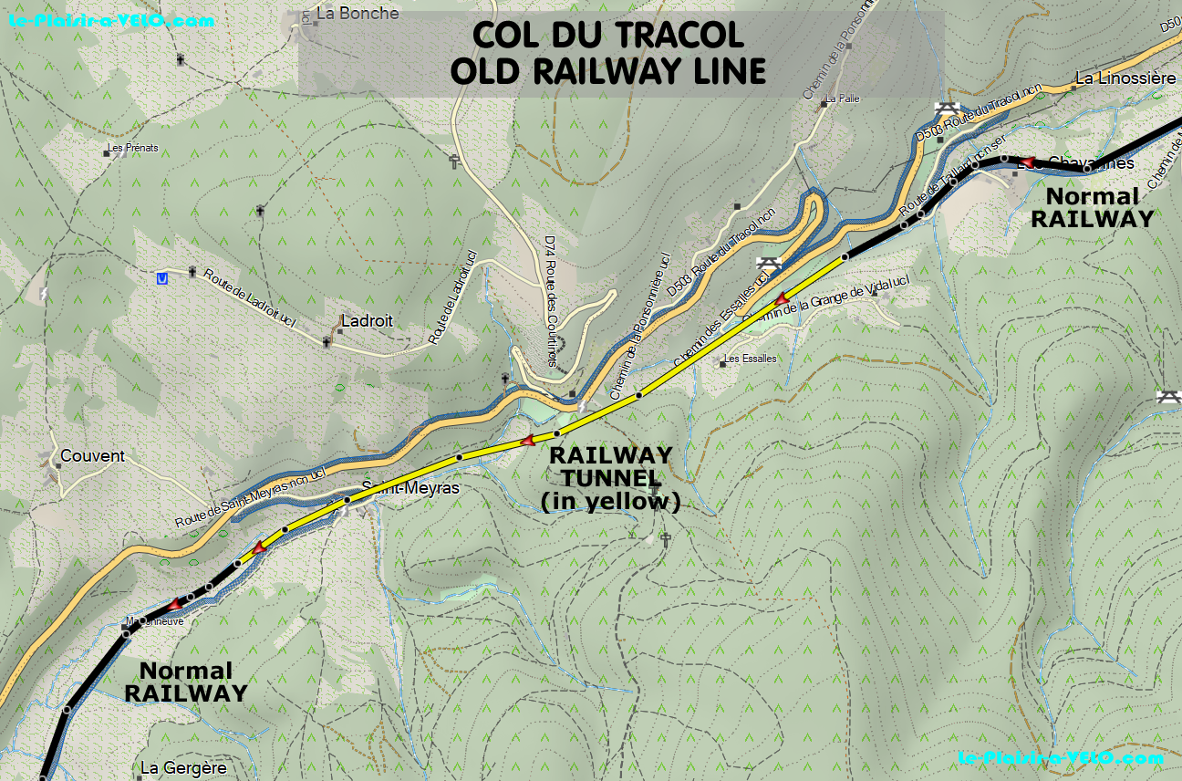
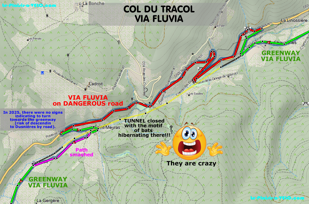
The descent of the pass towards Dunières is also very beautiful. The only downside is that we suffer from many portions on land with strong crevices and gullies generated by rain runoff (still French-style savings).
CONNECTION LAVOÛTE-SUR-LOIRE - SAINT-ARCONS-D'ALLIER
After moving from the Rhône to the Loire, we are now switching to the Allier.
The official connection between Lavoûte-sur-Loire and Le-Puy-en-Velay goes through the D103. It is a portion of the cycle route titled Vivez la Loire Sauvage. It is a high-traffic road with a narrow cycle lane (line of paint thrown on the ground). The best solution is to leave the Via Fluvia between Beaulieu and Lavoûte-sur-Loire, shortly before Les-Longes; and to go through Malrevers, Fay-la-Triouleyre and Plaisance.
Le Puy-en-Velay is amazing and impressive with:
- the Cathedral Notre-Dame du Puy in which one accesses right in the middle of its Choir by the endless staircase that extends the very steep street.
- the Statue of Our Lady, immense and majestic, perched on its rocky dome.
- the Saint-Michel Chapel on its peak.
From Puy-en-Velay to Saint-Arcons-d'Allier we have zigzagged a bit to avoid on one hand the roads with too much traffic and to minimize the accumulation of elevation (high point at 1 100 m near Beyssac).
In the very long descent (15 km) to Saint-Arcons-d'Allier via Siaugues-Saint-Romain the distant panoramic views are fantastic.
VIA ALLIER
The route of Via Allier did not seduce us with too many roads that were too busy and moderately pleasant. But we were able to admire in passing the magnificent Saint-Julien de Brioude Basilica, the Saint-Austremoine Abbey of Issoire, the magnificent buildings of Vichy.
We turned uselessly towards Clermont-Ferrand, because the visit was completely obstructed by the generalized works of the city center.
CANAL DU BERRY, CANAL DE BRIARE and CANAL DU LOING
The Berry canal is pleasant from Montluçon to Saint-Amand-Montrond, then from Saint-Just to Bourges. This last section just opened in the summer of 2025.
The very short Briare canal is very natural and includes at its ends the impressive works of the Pont-Canal on the Loire at its beginning in Briare and its historic 7 locks at, the rightly named, Rogny-les-7-écluses.
The Loing canal has too many sections with backlated coatings.
THE SEINE
The Seine is often enchanting between Saint-Mammès and Corbeil-Essonnes. Then, until Juvisiy-sur-Orge, the route is completely erratic, even catastrophic, with very many paths blocked without proposed deviations.
The crossing of the leisure island of Port-aux-Cerises near Draveil between Juvisy and Vigneux-sur-Seine is very pleasant.
The penetration in Paris is not friendly, but functional and secure.
GPX SECTIONS
| SLIDESHOW of the section |
| ----------- SECTION ------------ | START | END | --- RTE-GPX --- (zip) |
| VIARHÔNA | Lyon | Andancette | GPX |
| Connection to Via Fluvia | Andancette | Annonay | GPX |
| VIA FLUVIA | Annonay | Lavoûte-sur-Loire | GPX + Divesion Bourg-Argental |
| Connection to la Via Allier | Lavoûte-sur-Loire | Saint-Arcons-d'Allier | GPX |
| VIA ALLIER | Saint-Arcons-d'Allier | Moulins | GPX |
| Connection to Canal du Berry | Moulins | near Montluçon | GPX |
| CANAL DU BERRY | near Montluçon | Bourges | GPX |
| Connection to Canal de Briare | Bourges | Briare | GPX |
| CANAL DE BRIARE | Briare | Rogny-les-sept-Écluses | GPX |
| CANAL DU LOING | Rogny-les-sept-Écluses | Saint-Mammès | GPX |
| THE SEINE | Saint-Mammès | Paris | GPX |
ACCOMODATIONS
Our accommodations have been Bed and Breakfast.
THE BEST BED AND BREAKFASTS
Among all, we must mention the best ones:
- IMAGINASOI Dunières : Estelle is a caring, passionate and exciting hostess. She combines kindness, availability, friendliness while being discreet. We were able to exchange and in a very friendly manner. His passion for his region is communicative. Her house is vast and she made us enjoy it for maximum satisfaction. It is a stage of happiness for all, and even royal for cyclists. Thank you Estelle.
- AUX 3 FORÊTS Bizeneuille : Evelyne and Patrick are 2 really exceptional hosts. Warm welcome and permanent attentions. Friendly and cordial exchanges. The room and common areas are very comfortable and tastefully decorated. Excellent breakfasts with quality and very fresh products.
- LA PAUSE 18 Jars : Great hostess, attentive and available for everything. The weather being very hot, Edith agreed to receive us from the very beginning of the afternoon. Following our proposal, we had great pleasure to dine in the garden with her. Thus we were able to exchange in a very friendly and cordial way. Moreover, it allowed us to leave for the cold by serving a great breakfast from 6 in the morning! Including by making us a delicious omelette. A very big thank you. Warmly recommended.
- AMBIANCE SEINE Thomery : Laurence and Andrew are 2 charming and attentive hosts. Everything is done to make you feel good. The apartment is comfortable and very well equipped. The view of the Seine is great and the perfect quiet. Small terrace garden available.
THE ONLY PITIFUL GUEST ROOM
On the other hand, the MAISON ANGULUS of Montcresson was PATHETIC. We were in the middle of a heatwave. To avoid suffering from the heat, all the B&Bs accepted our request to arrive in the early afternoon (leaving very early in the morning), before their standard arrival time. Like everywhere we have indicated that if the room was not ready, it was not a big deal, the main thing would be to be able to relax in the common areas. But they categorically refused.
More serious, they were MISLEADING: as everywhere we had booked under condition of the provision of a secure lockable room to park our expensive bikes. In the evening, while going to pick up our VAE chargers, we were astonished to find that one of the multiple doors of the garage only closed with a small piece of wire. And the DIY was so poorly done that the door could open, leaving it easy to cut the thread with a small pincer and then enter. It took a discussion (and threatening to call on the customer service Booking) to finally have a satisfactory place.
For breakfast, the cheese was mini-babybel for the kid. At the price of the room, it’s really VERY CHEAP.